Friday 29 January 2016

Will skies be clear over southern Ontario Friday night?
It looks like skies will most likely be clear during the early evening over most regions, followed by increasing cloudiness by midnight.
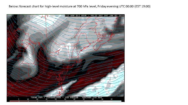
During early evening, a weak high pressure ridge over southern Ontario will be contributing dry air and diminishing winds, until high-level moisture moves eastward over southern Ontario (illustrated below for early evening) ahead of Saturday’s low pressure trough. Mostly clear skies are likely, except for regions southeast of Lake Huron and Georgian Bay, where lake-effect cloudiness may cause cloudy skies during early evening.

More substantial mid-level moisture that is forecast to move eastward (illustrated below for the hour after midnight) is likely to cause cloudiness over southwestern regions by late evening and all regions by or after midnight.


Monday 25 January 2016

Will skies be clear over southern Ontario Monday night?

Skies could become partly clear for several hours after sunset over some regions, before widespread cloudiness moves over southern Ontario later in the evening. However, the break in cloudiness after sunset will most likely have some mid-to-high level cloudiness present (illustrated below for high-level moisture at the 500 hPa level) but skies may be clear enough for brighter stars and the waning gibbous moon to be visible and potentially give the impression of clear skies.


Saturday 23 January 2016

Will skies be clear over southern Ontario Saturday night?
Clear skies are likely to continue over most regions until high-level cloudiness starts to move eastward over southern Ontario later in the evening.
The images below illustrate the high moisture that is forecast to move over southern Ontario ahead of a low pressure trough which is expected to move over the central Great Lakes region by Sunday morning. Meanwhile, south of Georgian Bay and Lake Huron, more extensive lake-effect cloudiness is likely to cause low-level cloudiness during most of the night.


Tuesday 5 January 2016

Will skies be clear over southern Ontario Tuesday night?
Clear skies are expected.

Some high cloudiness is likely to move over southern Ontario after midnight and before dawn (illustrated below).


Monday 4 January 2016

Will skies be clear over southern Ontario Monday night


Clear skies are expected, with a strong high pressure ridge moving over southern Ontario (illustrated below) providing a cold and dry airmass with strong subsidence that is likely to suppress any low-level lake-effect clouds during the early evening near the Great Lakes. By Tuesday morning, high-level moisture is forecast to move eastward over the Great Lakes region and may cause some high clouds to appear.


Sunday 3 January 2016

Will skies be clear over southern Ontario Sunday night?
Partly clear skies seem likely, except for more cloudiness southeast of Lake Huron and Georgian Bay due to lake-effect cloudiness flowing downwind from the warm waters (illustrated below for low-level moisture at the 850 hPa level). Elsewhere, skies are likely to become partly clear due to diminishing mid-level moisture during the early evening (illustrated below for the 700 hPa level) although another region of mid-level moisture is forecast to move southeastward across southern Ontario after midnight and could cause increasing mid-level cloudiness (over regions that are not under low-level lake-effect cloudiness).


Friday 1 January 2016

Will skies be clear over southern Ontario Friday night?

Skies may become partly clear by mid-to-late evening over regions near Toronto and GHTA as moisture at low and mid-levels decreases during the evening for several hours, until moisture and cloudiness increases again. The charts below show the diminishing moisture at low and mid levels during the evening. Other factors contributing to partly clearing skies include subsiding motion (contributing to sink and dry the clouds), lack of a jetstream overhead, and moderate winds (preventing fog formation overnight). Skies could remain cloudy due to low-level cloud below a thermal inversion (near the 850 hPa level) which might prevent vertical mixing that would allow the low cloud to dissipate.